Overview
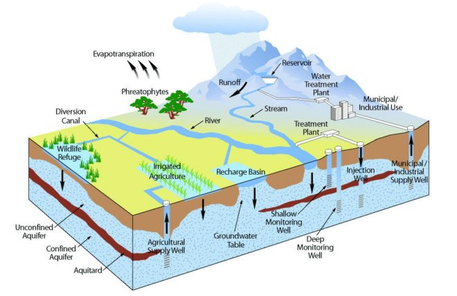 Groundwater is subsurface water that occurs below the water table within geologic formations that are saturated (all pore spaces filled with water rather than air). Most groundwater exists in tiny pore spaces between grains of rock or sediment that comprise aquifers, which are geologic formations that can store and transmit water in usable quantities.
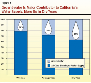
Within California, groundwater satisfies about 35% of fresh water demand, under “normal” climate and current land use conditions, but reliance on groundwater is highly variable across the state. The Colorado River hydrologic region (in the southwestern corner of the state) uses groundwater to satisfy <10% of normal freshwater demand, whereas the Central Coast hydrologic region (extending from Santa Cruz to Santa Barbara) uses groundwater to satisfy >80% of normal demand. During drought periods, there is a commonly a significant increase in groundwater use, both in absolute terms and as a fraction of total freshwater demand.
 According to a recent study by the Legislative Analyst’s Office, during years where surface water is not available and rainfall is scarce, groundwater may provide up to 100 percent of irrigation water for certain areas and, where surface supplies are not accessible or economically feasible, groundwater can provide 100 percent of a community’s public water.
Most groundwater originates as precipitation (rain or snow) that falls to the ground, infiltrates, and is eventually recharged into an aquifer. The age of groundwater can be difficult to determine, in part because many aquifers contain a mixture of water having a range of ages. In general, shallower groundwater is younger than deeper groundwater. Groundwater tends to become saltier naturally as it ages and interacts with surrounding rock, but groundwater chemistry can also be influenced by human activities. Groundwater management focuses on both water supply and water quality.
Water Savings
 The most obvious way to save groundwater is to not pump it out of the ground. This can also be the cheapest way to improve groundwater resource conditions, if there has been excess extraction from a groundwater basin. Of course, reducing groundwater pumping generally requires finding an alternative supply. One obvious approach is to use surface water when it is available, and then switch to using groundwater when there is an inadequate surface supply. When this approach is practiced on a broad scale, it is referred to as “conjunctive use.” Resting groundwater wells by using alternative supplies can allow aquifer levels to recover, and can be considered a form of “in lieu” recharge.
But resting wells will not assure that water not pumped is “saved” for future use. For example, pumping of a groundwater well adjacent to a stream could result in capture of stream flow. In this case, pumping causes recharge, the flow of water from the surface into an aquifer. If all of the water pumped from a well comes from a nearby stream, then resting that well might not help to restore groundwater supplies. Also, pumping is not the only means by which water is removed from a groundwater basin. Groundwater outflow can occur by evapotranspiration (ET, water loss by evaporation and use by plants), baseflow to streams, flow into adjacent basins, or discharge to the ocean (for basins in coastal areas). In some cases, pumping of groundwater captures one or more of these flows.
Many groundwater managers and stakeholders are concerned about limiting damage that can be done to groundwater resources if extractions exceed the “sustainable yield” of an aquifer. There are many definitions for “sustainable yield,” but the most widely accepted by practicing hydrologists is the amount of water that can be pumped over the long term without causing unacceptable harm. In general, sustainable yield is less than natural recharge. Of course, what is “unacceptable” is open to discussion, and harm can be measured using a number of physical, economic, political, legal, or social metrics. There are similar terms like “safe yield” and “basin yield” that are also commonly used.
Groundwater overdraft is a condition within a developed groundwater basin in which the amount of water pumped over the long term exceeds the sustainable yield of the basin. Overdraft can lead to numerous problems, including lowering of water levels, ground subsidence, loss of aquifer storage, seawater intrusion, and a reduction in groundwater quality.
What might be sustainable in a basin at one time may not be sustainable at another time, for example if inputs (like recharge) are reduced. Thus overdraft can occur even when there is relatively little pumping, or when pumping has stayed the same. The most accurate way to tell if there is overdraft is by monitoring water levels in aquifers over the long term. If water levels go down year after year, and do not rebound robustly when pumping stops or recharge occurs, there may be a problem with overdraft. In addition, overdraft can occur even if there is no net imbalance between annual inflows and outflows, or if pumpage is distributed in such a way as to lead to problems (for example, being concentrated along the coast).
Increasing Supply
 The primary input into an aquifer is called “recharge.” Not all water that infiltrates into the ground becomes recharge; some of this water goes into soil pores (above the water table), and some is lost to evaporatranspiration (ET). Groundwater recharge occurs in different parts of each basin, but exactly where recharge occurs, how recharge occurs, and how quickly recharge occurs remains unknown in many aquifers. Of all the primary flows in the hydrologic cycle, recharge is the hardest to measure and (arguably) the only primary flow that can’t be measured remotely.
In many groundwater basins, recharge occurs around the basin edge, where aquifer units are exposed at the surface or present below a thin soil layer. Recharge also commonly occurs through the beds of streams and rivers, particularly where they have incised through fine-grained layers that sometimes form the top of an aquifer. Measuring groundwater recharge from streams is relatively easy, requiring mainly accurate measurements of stream flow at two or more locations and accounting for additional losses and gains. Measuring recharge more broadly in a basin is challenging. In many basins, recharge is estimated over a year or more by conducting a water balance analysis, accounting for all other source or sink terms, and the change in water level (storage), and then calculating the recharge term. This common approach can lead to large errors in the calculation of recharge.
Groundwater recharge can be enhanced through a variety of techniques, collectively known as artificial recharge. The two most common types are managed aquifer recharge (MAR) and aquifer storage and recovery (ASR). MAR involves the use of natural streams and rivers, or constructed infiltration basins or trenches, to introduce excess surface water to a location where it can recharge underlying aquifers. In some basins, irrigation returns comprise a significant fraction of annual recharge, and may be considered a form of MAR, particularly if intentional over-irrigation is planned. MAR can also be accomplished using injection wells. ASR is a specialized form of artificial recharge where water is injected into an aquifer using one or more wells, and subsequently recovered using the same wells. Individual forms of MAR and ASR systems offer distinct advantage and challenges, and all must be carefully designed, installed, and operated; following a careful evaluation of site conditions and processes. MAR and ASR systems that work well in one region may not perform well in another.
Water Quality
 Water supply and water quality are closely linked, because supply is defined based on water being usable. Some groundwater is naturally of low quality, particularly if that water is close to a source of salt (for example, immediately adjacent to the ocean, below a beach). Human activities can also lead to a reduction in water quality, either directly (such as pollution) or because of changes in hydrologic and geochemical conditions caused by pumping, limitations to recharge, or other processes. In fact, water quality includes a wide variety of characteristics, including temperature, sediment load (turbidity), solutes, gases, and biological constituents.
Contamination of groundwater resources can occur as point source or non-point source pollution. Point sources have a known location (and often time) of application, for example a landfill or a leaking underground tank. Non-point source pollution often is caused by widespread practices, such as salting roads or applying pesticides. As such, it can be difficult to both identify the proximal cause of non-point source pollution and to stop it from occurring.
Water quality standards are regulations that indicate how much of a particular substance can be in water in order for it to be used for a specific purpose. These can be set at federal, state, regional, or local levels. Standards can be set in terms of the concentration or sample-specific magnitude of a substance or condition that is permitted, or standards can be established to assess how much of a substance can be transported over a period of time. For example, many basins have established total maximum daily load (TMDL) standards for the transport of salts or nutrients, emphasizing the total amount that can be moved in a day rather than the instantaneous concentration at a moment in time.
There are many potential contaminants in groundwater, but some of the most common ones in California include salts, nitrates and other nutrients, bacteria, metals, organic solvents, and pesticides. Sources for these compounds include septic systems, landfills, leaking underground tanks, seawater intrusion, and common agricultural practices such as application of fertilizers and pesticides. Some toxic compounds occur naturally in groundwater, and these may become more concentrated or diluted as a result of human activity. In general, it is more expensive and complicated to clean up (remediate) an aquifer than it would be to prevent initial contamination. Additional challenges can arise when flow occurs down and around or through groundwater wells, for example, allowing contamination from one aquifer to leak into another.
Regulation
California is unique among western states in how it manages groundwater resources, with three primary methods of management: local agencies, local governments, and court adjudication. Which of these methods is applied in a particular basin depends on local conditions and legal precedent. Local government entities manage groundwater largely on the basis of land use planning and police powers, often through elected county boards. Adjudicated basins are managed through court decree, often developed on the basis of lawsuits when stakeholders cannot agree how resources will be used. There is no statewide permit system for groundwater (in contrast to rules for managing surface water), and most property owners can exercise an “overlying right” to groundwater by drilling a well and extracting water. Recent regulations require groundwater level monitoring and reporting through the California Statewide Groundwater Elevation Monitoring Program (CASGEM). CASGEM, in accordance with a 2009 amendment to the Water Code (SBx7-6), was developed to establish a permanent, locally-managed program of regular and systematic monitoring in all of California’s alluvial groundwater basins.
All water use in California is subject to the requirement of “reasonable and beneficial use.” Water rights in California are usufructuary, which is a right to use water, but not to own it outright. Groundwater rights in California are classified according to water category (as defined in the state constitution): underflow of a surface stream, underground stream, and percolating water. The first two of these categories are managed as surface water, whereas the third is subject to distinct rules and considerably less statewide statuary control. Absent evidence to the contrary, groundwater is assumed to be percolating groundwater and not an underground stream.
The primary forms of groundwater rights are overlying, appropriative, and prescriptive. The first is associated with land ownership. The second allows water to be used off property, for example, by a municipality, is commonly defined on the basis of historical use, and generally requires that appropriative extraction be applied to surplus of overlying needs. A prescriptive right is one that is acquired by someone who openly uses water for which another party has an existing prior right.
Sustainable Groundwater Management Act
In 2014 California lawmakers passed the Sustainable Groundwater Management Act (SGMA), that aims to protect groundwater resources by allowing local agencies the authority to protect groundwater. You can learn more about the law in this SGMA Handbook published by the Water Education Foundation. The Department of Water Resources made this video on SGMA and added an updated video in April 2018. The UC Agriculture and Natural Resources group also created a video on SGMA.
Resources
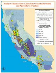
Addressing Nitrate in California’s Drinking Water
This report and associated documents and links provides an up-to-date assessment of the nature of nitrate contamination, potential sources, and what actions may be needed to get water quality to meet key standards, with an emphasis on the Tulare Lake Basin and the Salinas Valley.
Association of California Water Agencies, A Framework for Groundwater Management
The Association of California Water Agencies is the largest statewide coalition of public water agencies in the country, comprising more than 400 public agency members, who collectively manage about 90% of the water delivered to cities, farms, and businesses in California. Documents on this page were developed with an emphasis on local control and regulation.
This system provides access to groundwater management data and plans developed in basins throughout California. Through this portal, you can access a geographic information system that lets you search for and view a wide variety of data types.
California Department of Water Resources, Groundwater Information Center
This site has a lot of good information about groundwater in California, and about groundwater as a resource in general, with a good glossary of terms, information on well standards, and an overview of management schemes. There is a link to DWR “Bulletin 118”:(California’s Groundwater), which is nominally the authoritative statewide survey of groundwater basins and conditions. Bulletin 118 has not been updated since 2003, and there remains a lot that is unknown about groundwater conditions around the state. It is also worth looking at “Bulletin 160”: (Water Plan Update, information below), which has new information on groundwater conditions and use.
California Department of Water Resources
Since releasing the Integrated Water Resources Information System (IRWIS) to the public, a page has been created to provide a list of useful, alternative resources, tools and web pages related to groundwater management and the Sustainable Groundwater Management Act. You can find out who your Groundwater Sustainability Agency is by searching on this map.
California Groundwater
This site has numerous public and technical documents and a comprehensive listing of groundwater links, including basic information on groundwater mechanics and water quality, and connections to numerous federal, state, local, and non-governmental organizations with interests in groundwater and related issues.
California Water Blog
This timely and provocative blog is maintained through the Center for Watershed Sciences at UC Davis. It covers a broad range of water-related topics, including groundwater issues. The writing is opinionated, pointed, and lucid.
California Water Plan
The California Water Plan (DWR Bulletin 160) is updated about every five years. Historically, the California Water Plan has focused much more on surface water than groundwater, but recent editions have included more detailed groundwater information. As of when this text is being written (2021), the 2018 update of the California Water Plan is the latest official version. The Water Plan contains overview chapters on the full state, plus separate detailed assessments for each hydrologic region of the state. The Water Plan discusses historical and current patterns of use, surplus, and deficit, and describes how California will meet water demand in coming years.
Groundwater Resources Association of California
The Groundwater Resources Association of California (GRA) comprises scientists, engineers, and others involved in in the assessment, development, quality and management of the state’s groundwater resources. The GRA holds regular meetings and offers short courses on a range of technical topics, and also provides advice to agencies and groups on groundwater resource issues. The GRA publishes a regular newsletter with updates on relevant topics (HydroVisions), and has a full time Legislative Advocate who works with the state legislature and regulatory agencies. The GRA published the authoritative guide to California Groundwater Management, and sells this report at their website.
Protecting Groundwater Through Agricultural Best Management Practices
This brochure describes best management practices to address agricultural groundwater contamination.
The Recharge Initiative
The Recharge Initiative is a focused effort to protect, enhance, and improve the availability and reliability of groundwater resources. These goals are being addressed through research, teaching, service, and outreach, in collaboration with partners from academia, federal, state, and local agencies, municipalities, and citizen stakeholder groups. This web site has links to recent scientific and technical studies, copies of presentations made for technical and public groups, and a list of frequently asked questions concerning groundwater and recharge.
The UC Extension Agriculture and Natural Resources provide a good resource on whole-watershed accounting, found here.
U. S. Geological Survey Groundwater Information
The U. S. Geological Survey conducts a wide range of groundwater related research and monitoring activities, and their website provides access to numerous information sheets, reports, data sets, and computer programs used to evaluate groundwater processes and conditions.
Water in the West
Stanford’s website that provides scientific research and applied solutions to the growing water crisis in the west.
SGMA Resources
Department of Water Resources Sustainable Groundwater Management Act
DWR’s main SGMA page and SGMA portal, which houses official information submitted by GSAs and allows for public comment. To identify your local Groundwater Sustainability Agency, see DWR’s GSA Map, which includes points of contact for each GSA and links to each GSA website.
Flood-MAR
Flood Managed Aquifer Recharge (Flood-MAR) is an integrated and voluntary resource management strategy that uses flood water resulting from, or in anticipation of, rainfall or snow melt for managed aquifer recharge (MAR) on agricultural lands and working landscapes.
Groundwater Exchange
The Groundwater Exchange is a central, collaborative, and publicly accessible online resource center connecting water managers, water users, and community members with tools and resources to support the design and implementation of effective Groundwater Sustainability Plans under California’s Sustainable Groundwater Management Act. The Groundwater Exchange is a program of the California Water Library.
Groundwater Information & Educational Resources
Included is a UC Extension presentation providing a high-level explanation of SGMA’s structure and functions.
Public Policy Institute Water Policy Center
The Public Policy Institute “spurs innovative water management solutions that support a healthy economy, environment, and society” through independent research and engagement of stakeholders. See their Water Policy Blog and access the 2018 report, Replenishing Groundwater in the San Joaquin Valley.
The Sustainable Groundwater Management Act challenges the diversity of California farms
This 2016 opinion piece from California Agriculture highlights potential impacts of SGMA on California farmers, including perspectives from three Central Valley Farmers.
Weathering Change: The Impact of Climate and the Sustainable Groundwater Management Act on California’s Water
View presentations from UC Davis’ 2016 conference on SGMA, including conversations around policy, implementation, and a farmer panel discussion.
[back to top]
Case Studies
Farmington Groundwater Recharge Program
The Farmington Groundwater Recharge Program is being run in eastern San Joaquin County, with a goal of putting 35,000 ac-ft of managed recharge into aquifers, mainly by field flooding, allowing recharge sites to be rotated throughout the project area.
Groundwater Banking
In the last decade, the number of water banks has grown as districts seek to take advantage of groundwater storage options and improve the management and reliability of often-scarce surface water supplies. Groundwater banking offers a valuable supply-side tool, particularly as a response to climate change impacts on water resources in California. This case study reviews groundwater banking efforts in the Central Valley, California.
Groundwater Management in the Pajaro Valley
Balancing groundwater and surface water use can be complex in regions where neither is abundant. To work towards sustainable groundwater management, the Pajaro Valley is in the process of implementing a variety of programs, including a combination of additional supplies developed through water recycling and reuse, new groundwater recharge and storage options, and more aggressive water conservation and efficiency. A critical component of the Pajaro Valley Water Management Agency’s conjunctive use program is data collection and analysis. In addition, local stakeholders are involved in a “Community Water Dialogue” and the basin management planning process to improve the knowledge base and find shared solutions.
Pajaro Valley Water Management Agency, Basin Management Plan
The Pajaro Valley Water Management Agency is a “special act” agency established by the California legislature to resolve the groundwater overdraft problem in the Pajaro Valley, in the coastal Monterey Bay region. This basin management plan provides a nice example of how different management options are compared by cost, complexity, legal impediments, risk, and other factors. One of the projects being run by the PVWMA to improve groundwater conditions is the Harkins Slough managed aquifer recharge system. These three studies (Racz et al., Schmidt et al., Schmidt et al.) look at that complexity of how infiltration rates vary spatially and with time as this system runs, and how water quality is improved during shallow infiltration.
San Joaquin OFR Demonstration Site Monitoring and Analyses
This case study assesses the viability and effectiveness of on-farm recharge at seven different sites in the San Joaquin Valley growing grapes, walnuts, and pistachios. Their observations cover salinity, oxygen levels, and recharge rates of direct recharge and in lieu recharge, and guidelines and implementation tips for farmers are included in the conclusion.
Page Credit
Content for this page was originally developed by Dr. Andrew Fisher, UC Santa Cruz Department of Earth and Planetary Sciences. Various others have since contributed content.